GEM SYSTEM: NEXT-GENERATION GROUNDWATER EXPLORATION, MAPPING & OPTIMIZATION
The paramount challenge of groundwater is overcoming mankind’s very limited understanding of it and our inefficacy in optimizing it in a sustainable manner. That’s why making wise decisions about groundwater depends on reliable intelligence throughout the management process – from resource evaluation, to wellfield management to aquifer protection and remediation. The Hydro Nova GEM System has been developed to solve the critical groundwater intelligence issues of timeliness, precision and complexity under a single platform. This approach integrates technology and services for groundwater intelligence, development, optimization and protection, and ensures that technicians, specialists and decision makers have the actionable insights they need to make time-sensitive, high-risk decisions about their groundwater.
About the Groundwater Exploration and Mapping (GEM) System
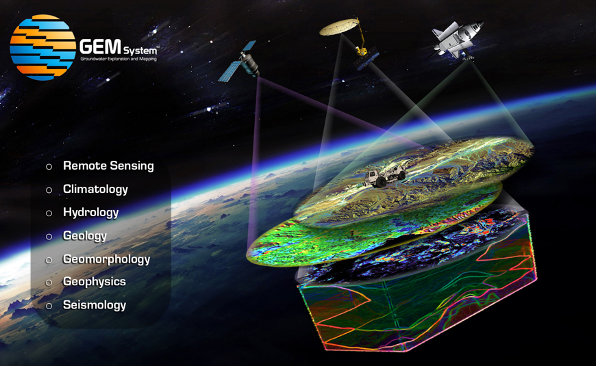
GEM – the Groundwater Exploration and Mapping System – is the game-changing sub-surface intelligence gathering and simulation tool developed by Hydro Nova to explore, measure and map groundwater resources. This groundwater measurement tool provides near real-time synoptic data over a wide operational area and depth range, while retaining the ability to assess smaller scale current features of interest. The data and derived products can support a wide range of technical, industrial, environmental and engineering needs.
Capabilities
GEM uses an innovative measurement to significantly enhance the characterization and understanding of sub-surface water. The system measures entire groundwater systems using both indirect and in situ methods, characterizing aquifer features and dynamics from a few centimeters below the surface to as deep as a several thousands of meters. The system integrates a wide range of latest groundwater observation and detection techniques, including geospatial, radar, airborne, seismic, hydrogeophysics, as well as exploration drilling and down-hole imaging, providing an unparalleled geographic coverage and geologic versatility.
With more data generated comes the need for smart data processing. The GEM System employs a unique big-data processing technique to process the immense quantity of data that these advanced measurements techniques afford. Conventional methods of data processing would require “stitching” these individual datasets into a composite, creating gaps and dissonance in the interpretation, thus increasing the surveyor’s reliance on a priori knowledge and raising the prospect for human error. GEM avoids this issue by applying unique data handling formulas to process large amounts of data from multiple modalities and platforms concurrently, while measuring different groundwater properties at different depths and formulating a single coherent characterization of the complete subsurface system.
A key functionality of GEM is solving a wide range of complex problems regarding groundwater use and optimization. The system seamlessly integrates data measurement with simulation and tool development under the same GIS environment. The system uses leading edge numerical and stochastic modeling to extract high-quality information about near-surface and deep formation groundwater and simulate a range of complex conditions, lending the system a versatile range of critical problem-solving capabilities: geological and geomechanical issues such as structural, subsidence, compaction, consolidations, faults and stress deformation; and hydrogeological and hydraulics issues such as multi-aquifer prediction, recharge and discharge zones, storage and retrieval of waste water, flow prediction, transport, brackish and saltwater intrusion, simulation of shallow, mid-range and deep aquifers over large regions.
The GEM’s tools development module processes data and synthesis, allowing a suite of tools to be tailored for specific groundwater management needs. A sample of tools includes: high-resolution groundwater mapping, groundwater data management systems, well field optimization systems, aquifer storage and recovery systems, groundwater optimization and planning tool, crop optimization tool, groundwater monitoring systems and seawater intrusion control systems.
Related Services
- Near real-time synoptic data for groundwater resources
- Large-scale advanced groundwater surveys and investigations
- Shallow, mid-depth and deep aquifer reserve forecast and advisory services for location-specific intelligence
- Advanced groundwater resources surveys, assessments and investigations
- Precision, high-resolution, 3D aquifer and groundwater resources mapping
- Managed Aquifer Recharge (MAR) analysis and Aquifer Storage and Recovery (ASR) systems design
- Well and borehole design, precision siting and planning
- Well field systems analysis and optimization
- Emergency groundwater systems design and delivery for humanitarian, crisis situations and contingency
- Groundwater re-use and re-injection systems analysis and design
- Groundwater economics and viability assessments
- Dynamic surface water and groundwater modeling
- Coastal zone groundwater modeling for seawater intrusion control and well optimization
- Groundwater use optimization tool design and industry-specific customization (agriculture, energy, environment, domestic, municipal)
- Design and installation of telemetry-platform based systems for real-time groundwater monitoring and optimization
- Client-tailored on-line groundwater data management and decision support systems
- Strategic planning and institutional support for groundwater management and policy making